


Summary
April 3, 1864. Shelby again attacked Steele's column at Okolona, but after a brisk engagement during a driving thunderstorm, the Union forces turned the Confederates back again.
The Route
▷ We previously began at Hollywood and Terre Noire Creek, and returned to the intersection of Arkansas 26 and Arkansas 53 in Hollywood, Arkansas, which is our starting point.
▷ Arkansas 26 at Arkansas 53, Hollywood ARTurn right (southward) off Arkansas 26 onto Arkansas 53. Continue 3 miles along 53.
▷ Arkansas 53 joins Arkansas 51, Clark County ARTurn right (southwestward) on Arkansas 53/51 and travel 0.8 miles.
▷ Arkansas 51 splits from Arkansas 53, Clark County ARContinue straight (southwestward) on Arkansas 51 toward Okolona when Arkansas 53 splits. Drive 7.5 miles.
▷ Arkansas 51/North Main Street at West 1st Street, Okolona ARIn Okolona, turn right (westward) onto West First Street, travel about 0.15 miles.
▷ W 1st Street at Smyrna Road/Clark County 16, Okolona ARTurn right (northward) onto Smyrna Road. Travel 0.8 mile along this gravel road to the Battle of the Bees marker, located on the left (west) side of the road.
▷ Battle of the Bees Marker (at side of road near barn), Clark County ARReturn 0.8 mile to W 1st Street.
▷ Smyrna Road at W 1st S, Okolona ARReturn to N Main Street/Arkansas 51.
▷ W 1st Street at S Main Street/Arkansas 51, Okolona ARTurn right onto N Main Street/Arkansas 51. Travel a couple of blocks.
▷ Fire Department, Okolona ARThe Okolona Fire Department is on the east (left) side of Arkansas 51, just south of the post office. There is a double-sided marker near the metal building. Follow Arkansas 51 about 10.7 miles (crossing I-30 around 8.5 miles) to US Highway 67.
▷ Arkansas 51 at US 67, Clark County, ARArrive at US 67.
▷ This brings us to our next point of interest is Elkins' Ferry.
Google Maps
Show my location on map
At the popup, you must allow your web brower (not us) to know your location.
Your location should update every 5 seconds.
This brings us to our next point of interest is Elkins' Ferry.
Okolona
The first settlers came into this area of Clark County in the 1830s and named Okolona after their previous home in northeastern Mississippi. Okolona got a post office in 1858 and once had stores, schools and banks, but it has declined steadily. The only business in the town today is the U. S. Post Office. The drive south down 51 and over I-30 to 67 is, however, historic and scenic.
Battle of the Bees Marker
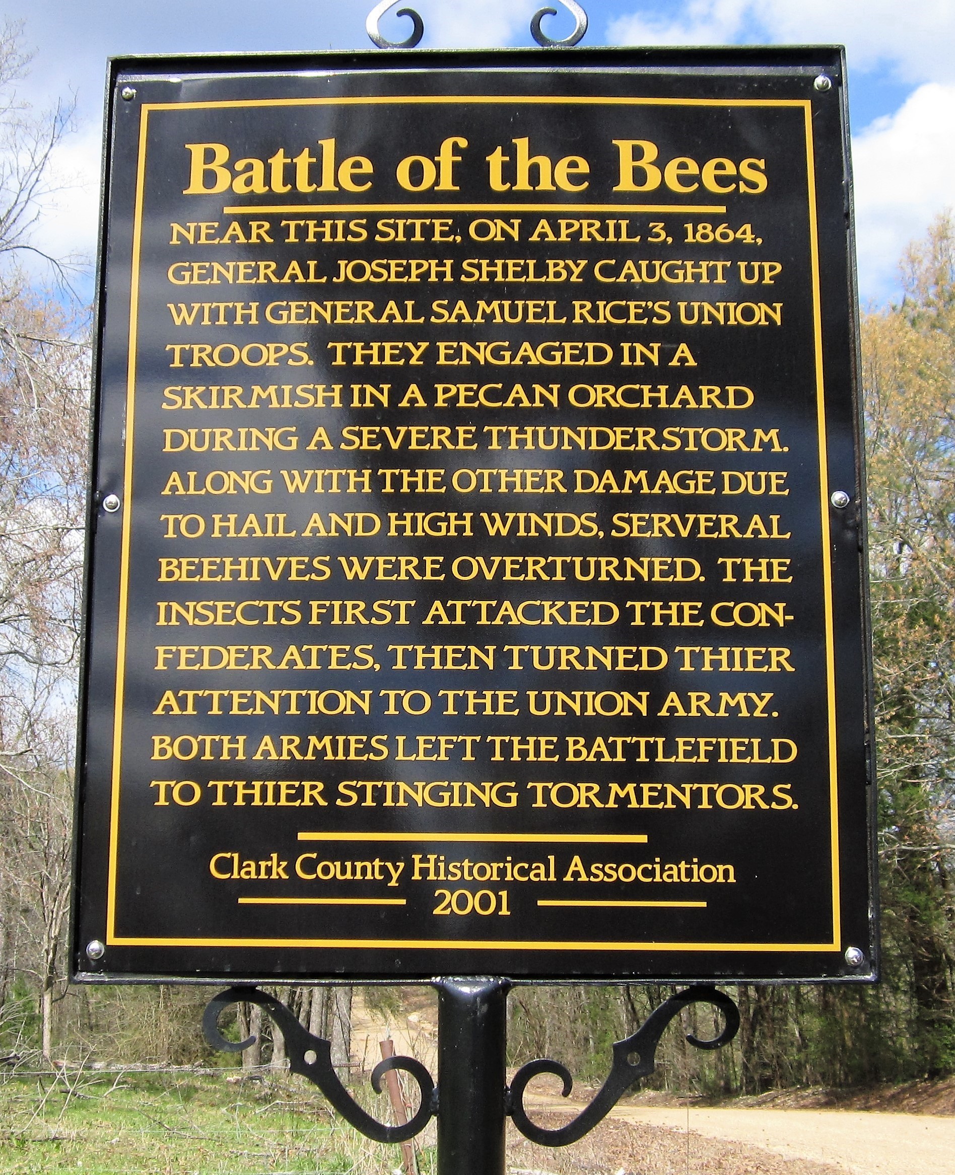
This battle site is immediately behind a private residence and its outbuilding and yard. A deep cut in the hillside marks the site of the old road just a few yards west of the current road. A marker on the west side of the road marks the site. The marker was installed in 2001 by the Clark County Historical Association.
Near this site on April 3, 1864, General Joseph Shelby caught up with General Samuel Rice's Union troops. They engaged in a skirmish in a pecan orchard during a severe thunderstorm. Along with the other damage due to hail and high winds, several beehives were overturned. The insects first attacked the Confederates. Then turned their attention to the Union Army. Both armies left the battlefield to their stinging tormentors.
Photo by Charles Todd
Skirmishes at Okolona Marker
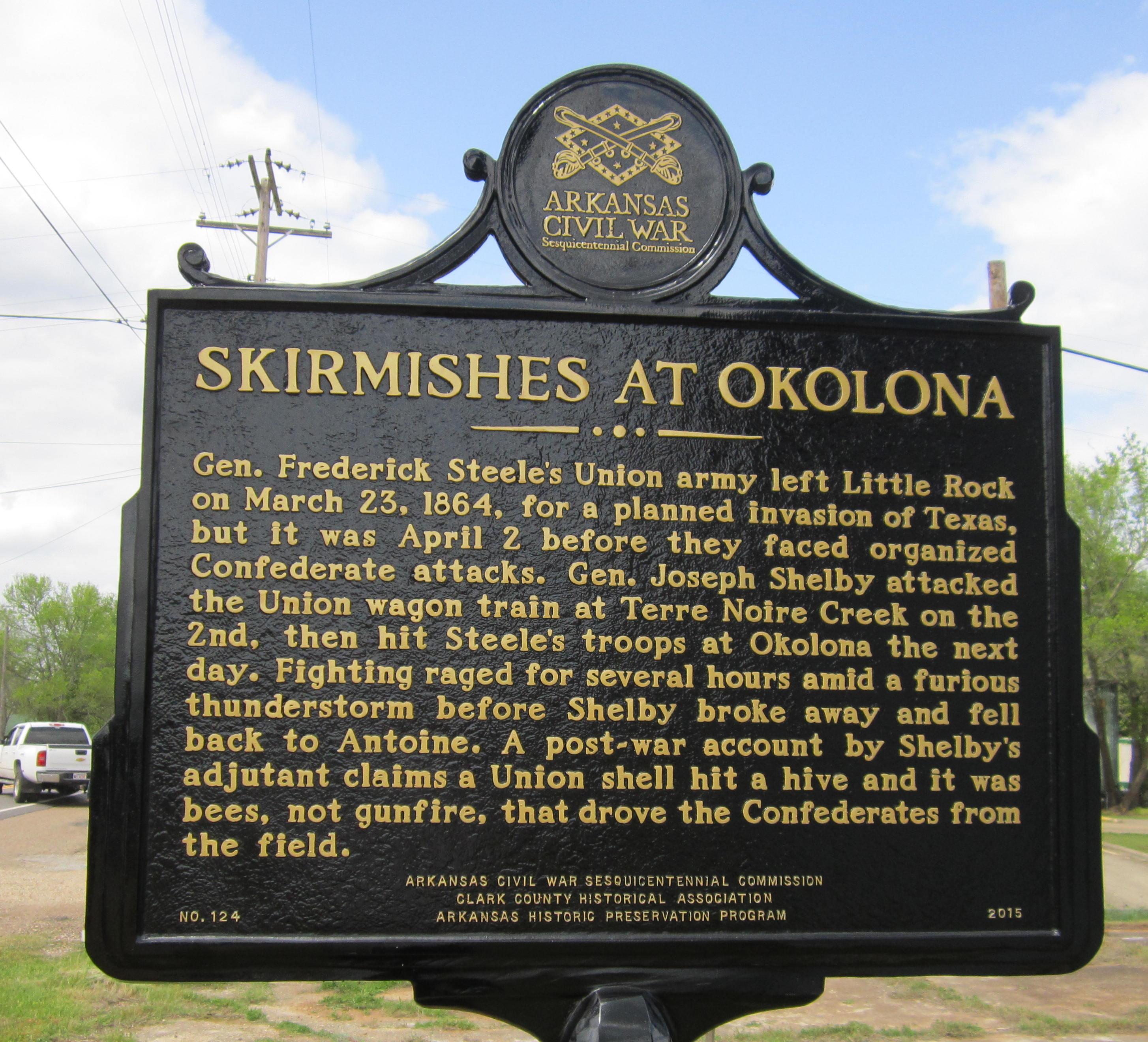
In Okolona, a Civil War Sesquicentennial two-sided marker is on the east side of the highway near the post office. It addresses the fighting at Okolona:
Gen. Frederick Steele's Union army left Little Rock on March 23, 1864, for a planned invasion of Texas, but it was April 2 before they faced organized Confederate attacks. Gen. Joseph Shelby attacked the Union wagon train at Terre Noire Creek on the 2nd, then hit Steele's troops at Okolona the next day. Fighting raged for several hours amid a furious thunderstorm before Shelby broke away and fell back to Antoine. A post-war account by Shelby's adjutant claims a Union shell hit a hive and it was bees, not gunfire, that drove the Confederates from the field.
Photo by Charles Todd
Fighting at Elkins' Ferry Marker
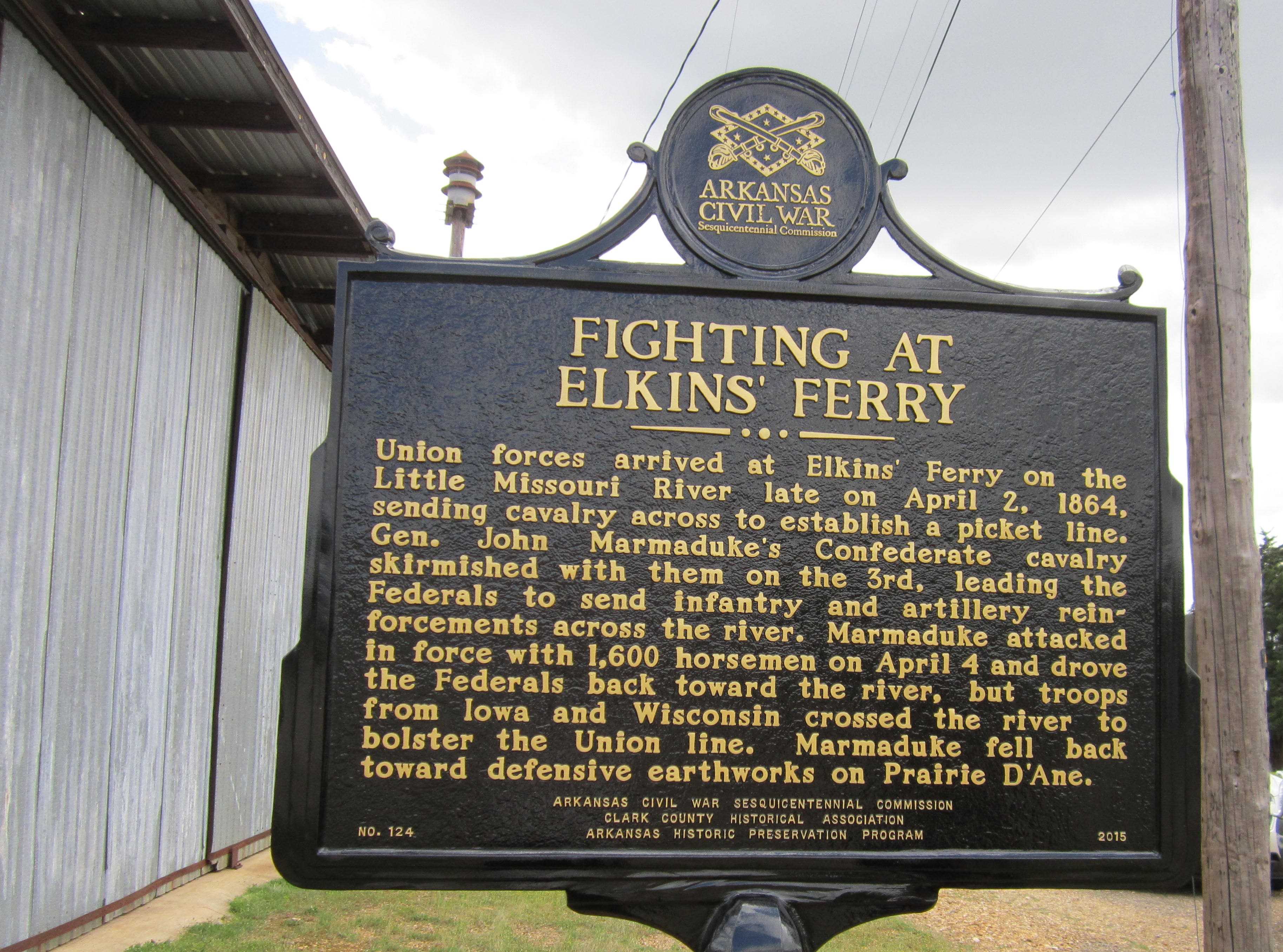
The other side of the marker chronicles the advance to Elkins' Ferry and the Little Missouri River:
Union forces arrived at Elkins' Ferry on the Little Missouri River late on April 2, 1864, sending cavalry across to establish a picket line. Gen. John Marmaduke's Confederate cavalry skirmished with them on the 3rd, leading the Federals to send infantry and artillery reinforcements across the river. Marmaduke attacked in force with 1,600 horsemen on April 4 and drove the Federals back toward the river, but troops from Iowa and Wisconsin crossed the river to bolster the Union line. Marmaduke fell back toward defensive earthworks on Prairie D'Ane.
Photo by Charles Todd
Roads to the River
The county roads to the Little Missouri are usable only for a short distance, and there is no longer a ferry or bridge over the river. The Byway follows other routes to approach Elkins' Ferry from the west side of the river.
Looking West Over the Hills South of Okolona
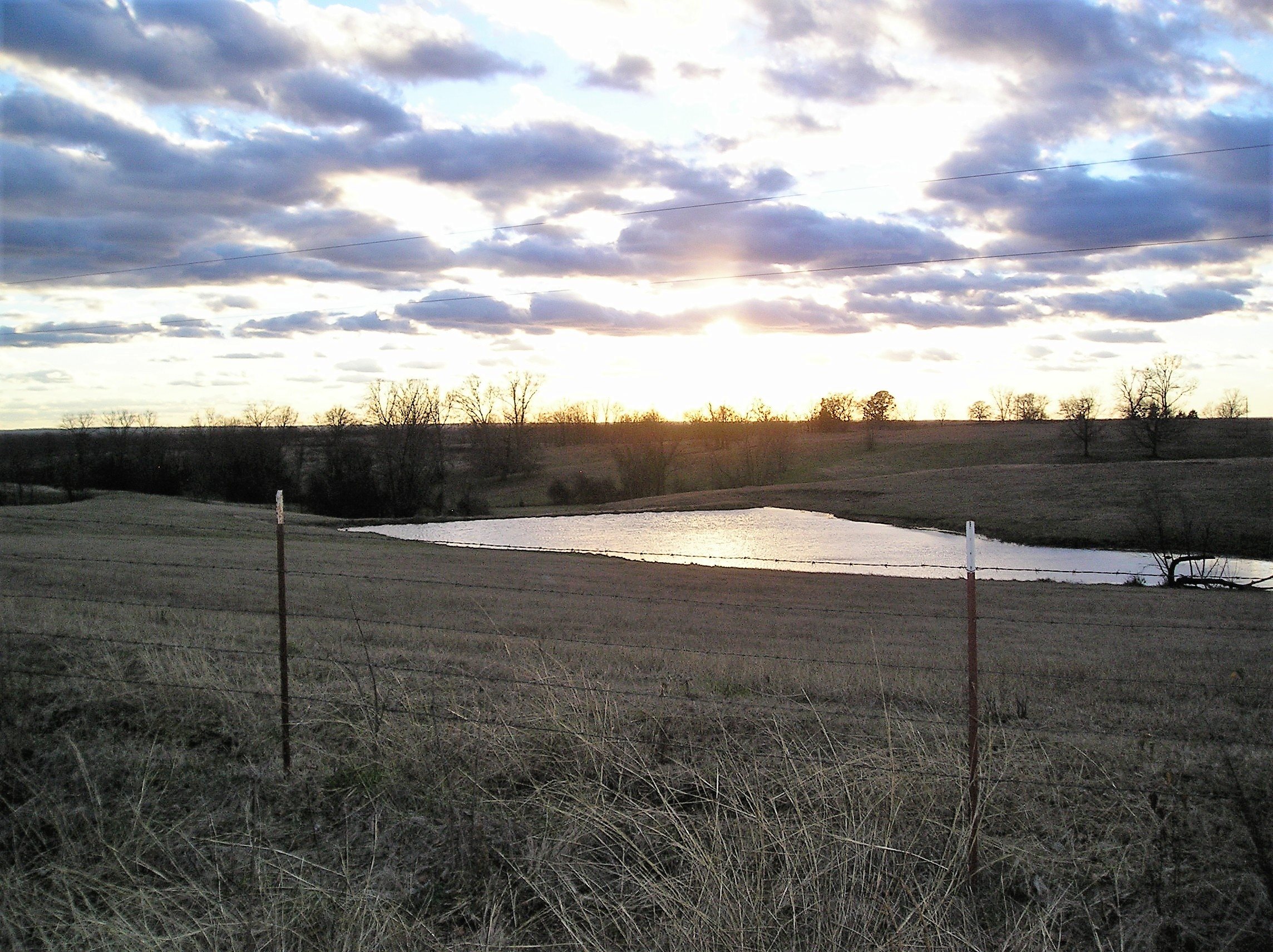
Sunset in the hills of western Clark County near the Little Missouri River.
Photo by Peggy Lloyd
Rome Cemetery on Highway 51 North of I-30
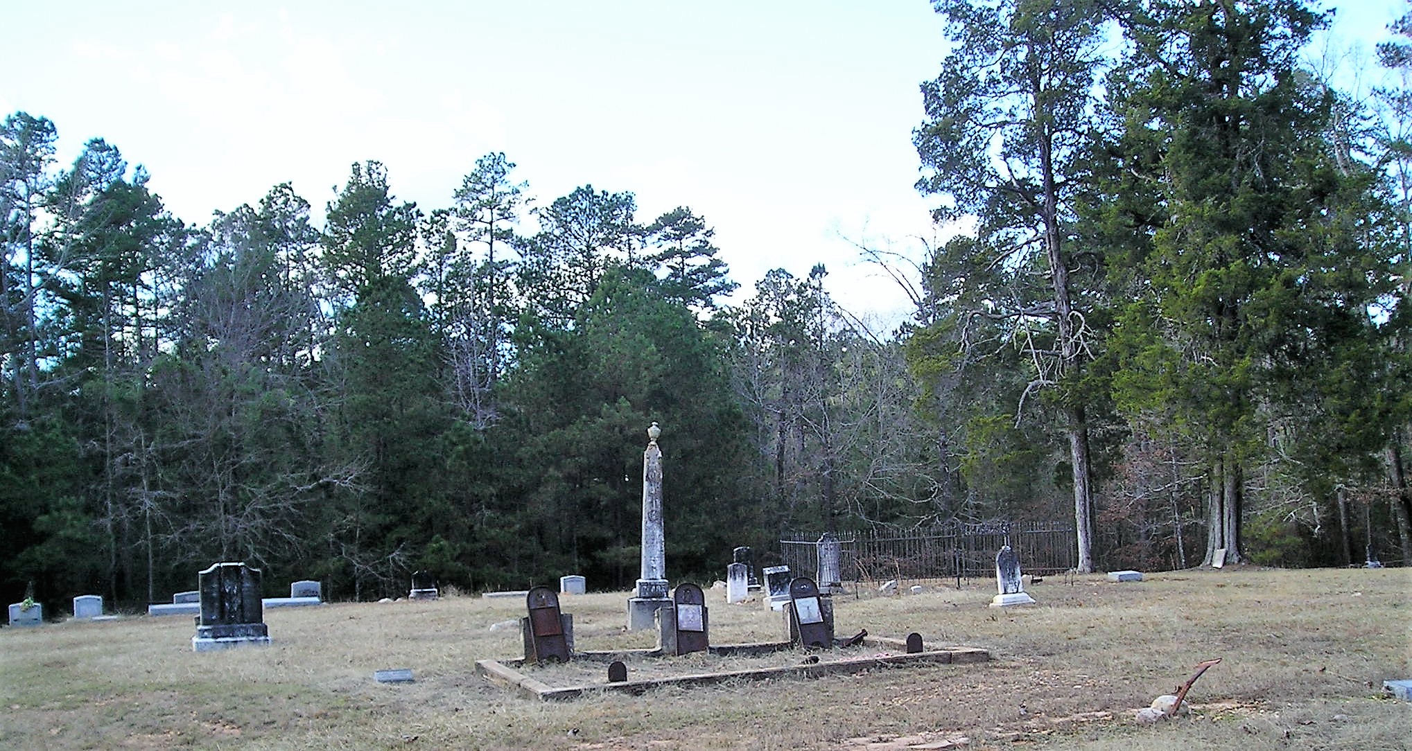
Rome was another early village along the road to Camden and had a post office as early as 1851. Today it is little more than two cemeteries, one White and one Black.
Up Next
This brings us to our next point of interest is Elkins' Ferry.