


Summary
The Confederate commanders at Prairie D'Ane, not realizing that General Steele's real objective was Shreveport, feared the Union Army planned to go to Washington and blocked the Camden to Washington Road.
The Route
▷ We previously visited Prairie D'Ane / Battle of Gum Grove and the Nevada County Depot and Museum on US 67 in Prescott, which is our starting point.
▷ Nevada County Depot and Museum, Prescott ARContinue southwestward on US 67 for 0.4 mile and turn right (northwestward) onto Arkansas 332.
▷ US 67 at Arkansas 332, Prescott ARFollow 332 for 11.2 miles through open pasture lands, across I-30 and the southwest portion of Prairie D'Ane into the woodlands of Hempstead County to the village of DeAnn.
▷ Arkansas 332 at Hempstead 212, DeAnn, Hempstead County ARContinue on Arkansas 332 for 1.1 miles to Arkansas 29. At this point, segments of the old Camden-to-Washington Stagecoach Road are not on paved roads or are not part of the modern road network. Therefore, an alternative route is necessary.
▷ Arkansas 332 at Arkansas 29, Hempstead County ARTurn left (southward) on Arkansas 29 and travel 5.4 miles to reach Arkansas 32.
▷ Arkansas 29 at Arkansas 32, Hempstead County ARTo continue your journey via the city of Hope, Arkansas, turn left (southward) onto Arkansas 32 for 1.2 miles into northern Hope, crossing I-30.
▷ Arkansas 32/N Hazel Street at US 278/W Commerce/Clinton Bypass, Hope ARTurn right (westward) onto W Commerce Blvd (Bill Clinton Bypass/U.S. 278) and continue 3/4 mile to the North Hervey Street intersection. Note: At this intersection, you are about a mile from the National Park Service's Bill Clinton Birthplace site. To get there (not part of this Scenic Highway), turn left (southeastward), go under the mainline railroad underpass, and the site is on the left (east).
▷ US 278/W Commerce at US 278/N Hervey Street, Hope ARTo continue to Washington, turn right at US 278/N Hervey Street and travel over I-30 for 8.5 miles into Historic Washington State Park.
▷ Hope Municipal Airport, Arkansas 278 at Arkansas 32, Hempstead County, ARThe Hope Municipal Airport is the south side of Highway 278 and dates from World War II as part of the Southwest Proving Ground established near Hope.
▷ US 278/Columbus Street at Arkansas 195 at Franklin Street, Washington ARIn Washington, at the junction of US 278 and Arkansas 195, turn right (eastward) onto Franklin Street and travel for three blocks.
▷ Franklin Street at Hamilton Street, Washington ARThe 1836 Courthouse is on the right (southeast), with parking available on the southwest side of the Courthouse. Return to Highway 278.
▷ Franklin Street at US 278, Washington ARTurn right (northwestward) onto US 278 for 0.4 mile to Carrigan St and the Washington Cemetery.
▷ Washington Cemetery, Washington ARThe Washington Cemetery is on the left (south) side of US 278 and a historic marker is near the highway. Return to Arkansas 332/US 67 in Prescott by (a) reversing the path along the Camden Expedition Scenic Byway, or (b) following US 278 East to Hope, then eastward onto I-30, or (c) following US 278 into Hope, passing the Bill Clinton Birthplace site, and then left (eastward) onto US 67 and northeastward to Prescott.
▷ Arkansas 332/US 67, Prescott ARTravel eastward on US 67 a few blocks to the intersection of Arkansas 24 (at the mural).
▷ US 67 at Arkansas 24, Prescott ARTurn right (southeastward) onto Arkansas 24/N Main Street.
▷ Railroad Crossing, Prescott ARCrossing the railroad track becomes Arkansas 24/S Main Street. Travel southeastward for 0.7 mile to the point where the curve begins.
▷ Arkansas 24/South Main Street at Ash Street, Prescott AROn Arkansas 24, Prescott.
▷ This brings us ready to proceed to the next point of interest, Moscow.
Google Maps
Show my location on map
At the popup, you must allow your web brower (not us) to know your location.
Your location should update every 5 seconds.
This brings us ready to proceed to the next point of interest, Moscow.
Washington, Confederate Capital of the State of Arkansas
At the time of the Camden Expedition, Washington was the seat of Confederate government in Arkansas and a supply center. Casualties from the fighting at Prairie D'Ane were taken to Washington for medical treatment or burial.
The Confederate commanders at Prairie D'Ane, not realizing that General Steele's real objective was Shreveport, feared the Union Army planned to go Washington and blocked the Camden to Washington Road. Citizens of Washington had similar fears. Confederate Governor Harris Flanagin sent the state papers across the Red River to Rondo, then in Lafayette County and now in Miller County. John R. Eakin, the editor of the Washington Telegraph who continued to publish his newspaper throughout the war, also took his printing press and type to Rondo for safekeeping. The anticipated invasion and possible burning of the courthouse did not happen. Washington remained in Confederate hands until the end of the war. When the 12th Michigan arrived in Washington in early June of 1865, they did not have to fire a shot and arranged a public meeting with the locals.
Under cover of darkness late on April 11 or early on April 12, General Sterling Price had withdrawn his forces to within eight miles of Washington to better defend the Confederate capital. On April 12, General Steele found the Confederate positions on Prairie D'Ane largely abandoned and turned toward Camden, using Thayer's newly arrived force as his rearguard. Some citizens of Washington also feared fighting with the coming of the Union Army and had fled to safer locations.
Historic Washington State Park has as its mission the study of Washington in the 19th century. Tours are available of many sites in the park including the courthouses, historic homes, churches, and the print and gun museums. The 1874 Courthouse serves as a Visitor Center. The park hosts many events and workshops throughout the year. Civil War Weekend occurs on the first weekend in November annually. Williams Tavern is open for lunch daily from 11 to 3 and serves dinner for special events. There are also several venues for special events such as meetings, weddings and reunions. Lodging is available at Coulter Farmstead and Grace Cottage---private B&Bs in the park, at The Old Jail---a B&B recently renovated by the park, and at motels and campgrounds in nearby Hope and the surrounding area.
Scenic Hayfields Along Washington Road
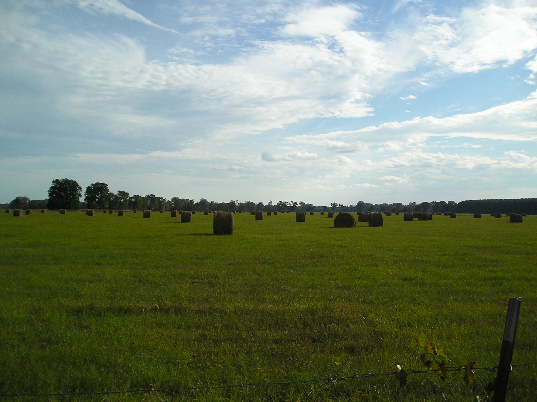
Scenic hayfields along Highway 332 west of Prescott and south of I-30.
Photo by Peggy Lloyd
Hope Municipal Airport
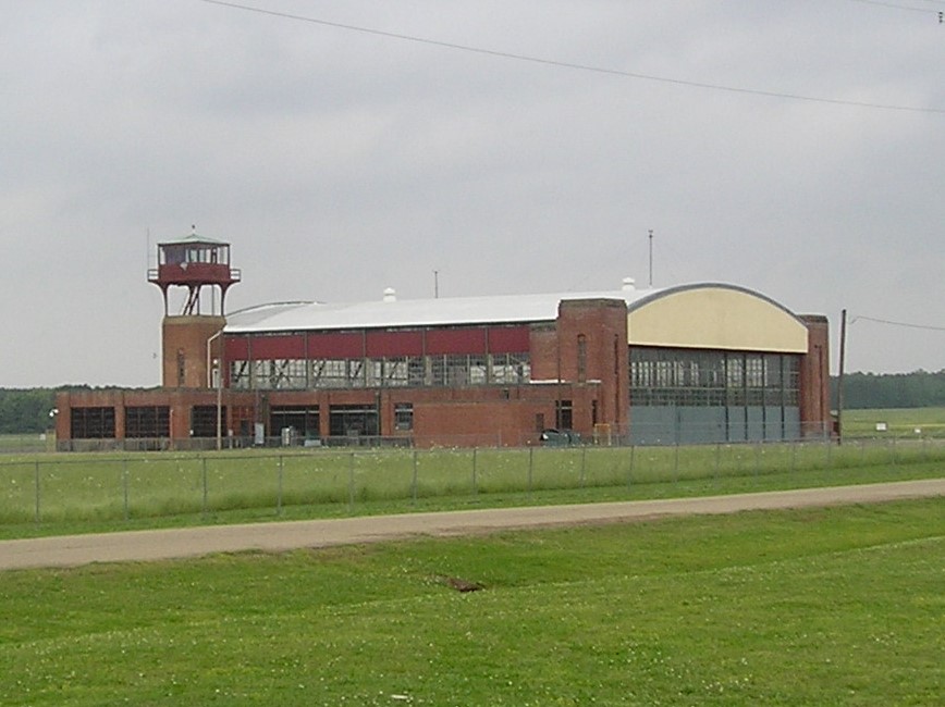
About halfway to Washington from Hope is the Hope Municipal Airport built by the U. S. government in 1941 for aircraft flying into and out of the Southwest Proving Ground (SPG). The SPG was in operation from 1941 to 1945 with the purpose of testing shells, bombs and artillery. The Hope Municipal Airport has 750 acres and was used also by the U. S. government as a site to park hundreds of FEMA trailers after Hurricane Katrina devastated New Orleans and other Gulf coastal areas in August 2005.
The airport lounge area in the 25,000 sq. ft. terminal building has a permanent exhibit on the Southwest Proving Ground in World War II with photos, a map of the entire SPG, a timeline of its activities and examples of the shells that it tested. The lounge is open 24/7, and aircraft can fly in at any time. The Proving Ground took 50,098.6 acres out of Hempstead County and displaced 404 families. It reached from what is now Highway 371 in northern Hempstead County to the airport lands. It also reached the outskirts of nearby Washington, now Historic Washington State Park. Highway 32 opposite the entrance to the airport leads into the center of the Southwest Proving Ground, now an industrial park, and to the incorporated town of Oakhaven, the former homes of Army officers at the Proving Ground during World War II.
Photo by Peggy Lloyd
1836 Courthouse
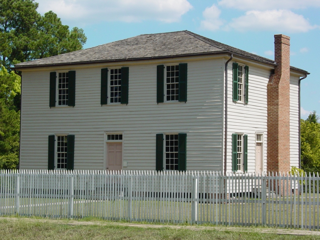
The Civil War Sesquicentennial marker entitled 'Confederate Capitol' behind the 1836 courthouse outlines the role of this historic courthouse in the Civil War:
Photo by Peggy Lloyd
Marker
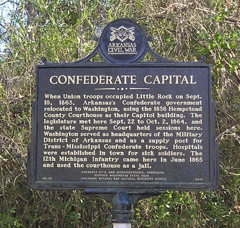
When the Union troops occupied Little Rock on Sept. 10, 1863, Arkansas's Confederate government relocated to Washington, using the 1836 Courthouse for their Capitol building. The legislature met here Sept. 22 to Oct. 2, 1864, and the state Supreme Court held sessions here. Washington served as headquarters of the Military District of Arkansas and as a supply post for Trans-Mississippi Confederate troops. Hospitals were established in town for sick soldiers. The 12th Michigan Infantry came here in June 1865 and used the courthouse as a jail.
Photo by Peggy Lloyd
Large Catalpa Tree at 1836 Courthouse
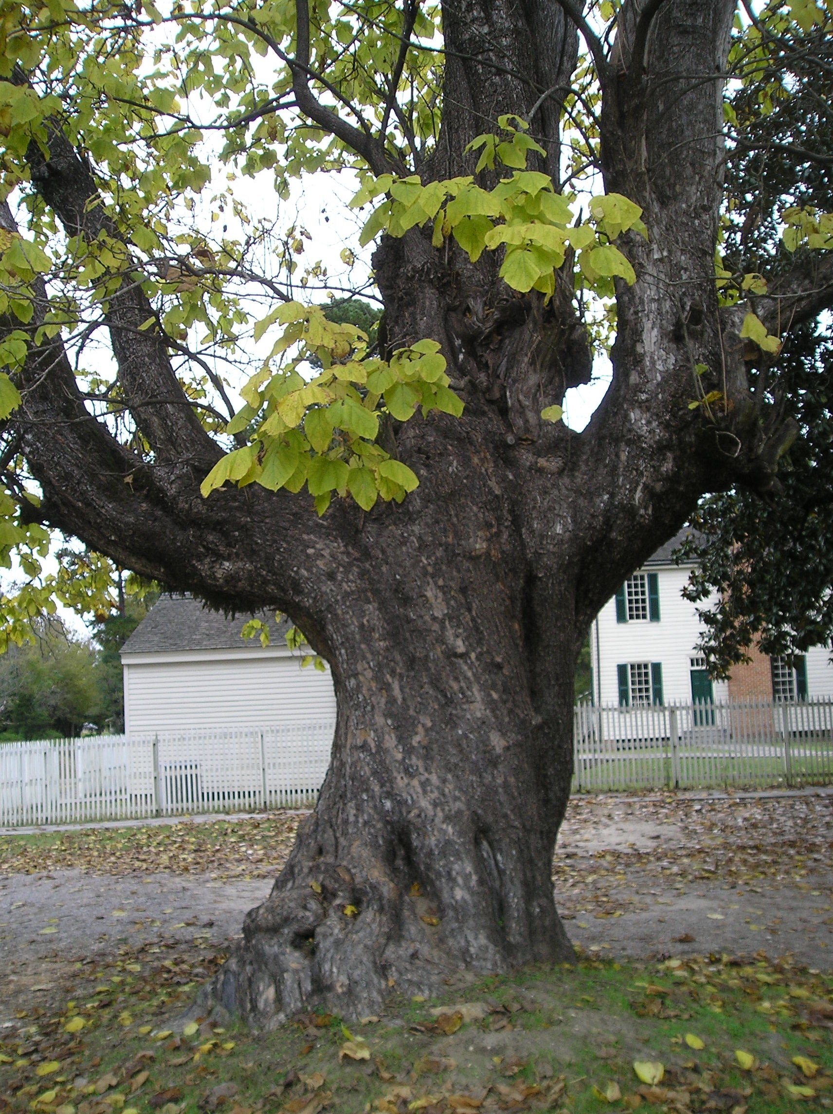
This catalpa tree stands south of the 1836 Courthouse on the side of the parking lot for the site. It is one of many large and remarkable trees in the park, including the famed giant magnolia directly across Franklin St. from the former Confederate Capitol.
Photo by Peggy Lloyd
Cemetery Marker
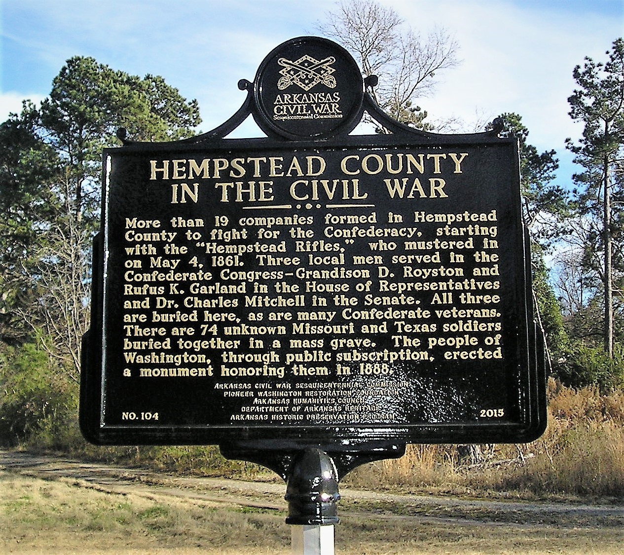
The Civil War Sesquicentennial marker entitled 'Hempstead County in the Civil War' stands near the cemetery entrance and notes the county's involvement in the conflict.
More than 19 companies formed in Hempstead County to fight for the Confederacy, starting with the 'Hempstead Rifles', who mustered in on May 4, 1861. Three local men served in the Confederate Congress -- Grandison D. Royston and Rufus K. Garland in the House of Representatives and Charles B. Mitchell in the Senate. All three are buried here, as are many Confederate veterans. There are 74 unknown Missouri and Texas soldiers buried in a mass grave. The people of Washington, through public subscription, erected a monument honoring them in 1888.
Photo by Peggy Lloyd
Up Next
This brings us ready to proceed to the next point of interest, Moscow.