


Summary
March 23-March 24, 1864. Steele's column marched through Benton on the way to Rockport and Arkadelphia.
The Route
▷ We previously began at The Little Rock Arsenal, ending on Arkansas 5 north of I-30 in Saline County, which is our starting point.
▷ Arkansas 5 becomes Military Road just north of I-30 at Benton ARContinue southwestward over I-30 on Highway 5 which becomes Military Road. Travel about 1.7 miles to Lee Cemetery located on the left (southwest) side of Military Road.
▷ Lee Cemetery on Military Road, Benton ARContinue southwestward for about 1.2 miles on Military Road and bear left onto North Main Street. The Shoppach House is on the left (east side of road).
▷ Intersection near Shoppach House, Benton ARContinue southward on North Main Street about two blocks to Conway Street. Be in the right lane.
▷ N Main St at W Conway St, Benton ARIn order to circle around the courthouse, turn right on West Conway (this segment is one way westward). Get into the left lane.
▷ W Conway Street at N Market Street, Benton ARAt North Market Street, turn left on North Market (this segment is one way southward) for one block. Historic markers are on the grounds of the courthouse (left, eastern side of street). If parking is not available on S Market St, turn left into the right lane of W Sevier Street.
▷ N Market Street at W Sevier Street, Benton ARFrom W Sevier Street, travel one block southward (If you turned onto W Sevier Street, continue straight to the end of the block then turn right onto S Main Street for the one block).
▷ N Market Street at W South Street, Benton ARTurn right (westward) onto West South Street, and travel about 0.8 miles, bearing right to go over I-30.
▷ W South Street crossing over I-30, Benton ARStay left around a circle on the northwest side of the overpass, then veer right.
▷ W South St at I-30 Frontage Road, Benton ARReady to continue on W. South St/I-30 Frontage Road.
▷ This brings us to the next point of interest, Saline River and Rural Saline County.
Google Maps
Show my location on map
At the popup, you must allow your web brower (not us) to know your location.
Your location should update every 5 seconds.
This brings us to the next point of interest, Saline River and Rural Saline County.
The Bryant & Benton Area
Now a busy extension of the Little Rock metropolitan area with shopping malls, fast food restaurants, businesses and modern subdivisions, the road to Benton was rural at the time of the Civil War with small communities. The City of Bryant was incorporated in 1892. The development of both Bryant and nearby Alexander along the Pulaski-Saline county line resulted from the coming of the Cairo and Fulton Railroad, later re-organized as the St. Louis, Iron Mountain and Southern Railroad, in 1874.
Geographical Center of Arkansas Marker
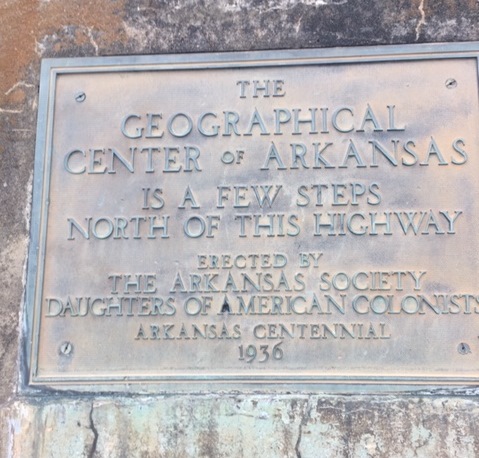
The geographical center of Arkansas is a few steps north of this highway.
Erected by the Arkansas Society Daughters of American Colonists.
Arkansas Centennial 1936
In Bryant on the north side of Highway 5 near the Pinecrest Memorial Park Cemetery is a landmark 1936 marker indicating the Geographical Center of the State of Arkansas. The Arkansas Highway Department, now the Arkansas Department of Transportation, installed it during the first Arkansas centennial of statehood.
Photo by Steve Perdue
Andrew Hunter House
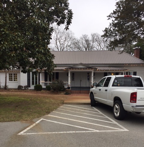
Believed to have been built about 1870, the landmark Andrew Hunter House is located on the north side of Highway 5 in Bryant just east of Reynolds Road (Highway 183). Andrew Hunter (1813-1902) became a Methodist pastor and one the most influential and respected figures in the development of Methodism in Arkansas both before and after the Civil War. He bought the house in 1870. It is on the National Register of Historic Places. Renovated, it now serves as a dentist's office.
Photo by Steve Perdue
Rowland-Lenz House
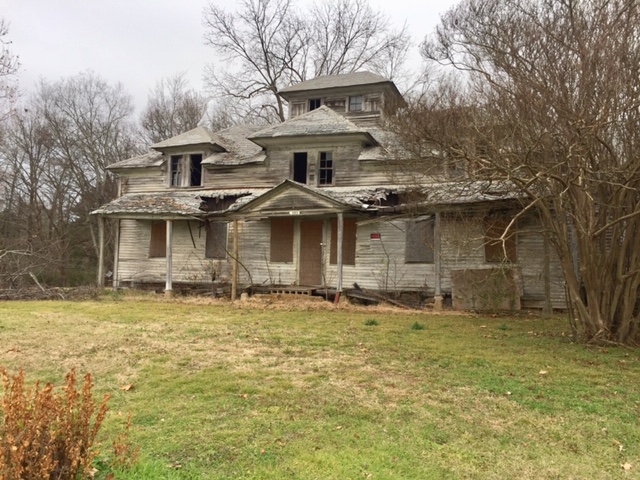
Built in late 1830s, the Rowland-Lenz house awaits renovation. It stands on the north side of Highway 5 northeast of Benton and a short distance southwest of Salem Road's intersection with Highway 5/the old Military Road. The Rowland-Lenz House witnessed the development of Arkansas as a state and the troop movements of the Union and Confederate armies in the region during the Civil War as well as more recent changes and growth. It is the oldest standing structure in Saline County.
Photo by Steve Perdue
George M. Holt Marker
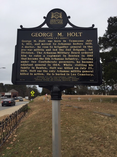
A two-sided marker in the northwestern corner of the Lee Cemetery near the Military Road remembers two Confederate officers.
George M. Holt was born in Tennessee July 4, 1831, and moved to Arkansas before 1859. A doctor, he rose to brigadier general in the pre-war militia and led the 2nd Brigade, First Division. The Arkansas Military Board ordered him to raise a regiment in Benton in 1861 that became the 11th Arkansas infantry. Serving under two Confederate governors, he became adjutant general in 1864. While visiting his family in Benton, Holt was killed on July 25, 1864. Holt was the only Arkansas militia general killed in action. He is buried in Lee Cemetery.
Photo by Steve Perdue
William Ayers Crawford Marker
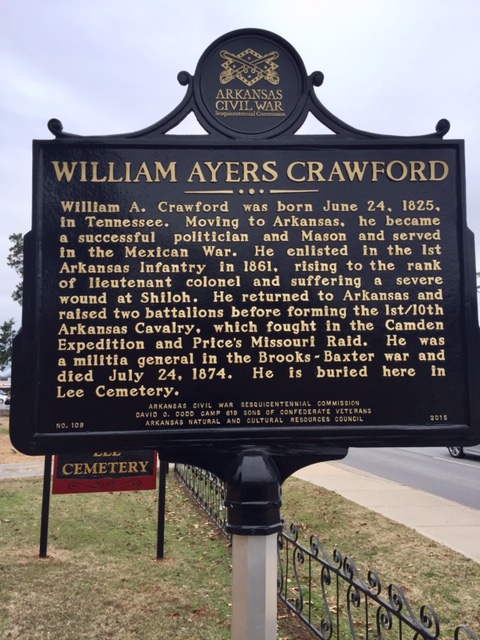
A two-sided marker in the northwestern corner of the Lee Cemetery near the Military Road remembers two Confederate officers.
William A. Crawford was born on June 24, 1825, in Tennessee. Moving to Arkansas, he became a successful politician and Mason and served in the Mexican War. He enlisted in the 1st Arkansas Infantry in 1861, rising to the rank of lieutenant colonel and suffering a severe wound at Shiloh. He returned to Arkansas and raised two battalions before forming the 1st/10th Arkansas Cavalry, which fought in the Camden Expedition and Price's Missouri Raid. He was a militia general in the Brooks-Baxter War and died July 24,1874. He is buried here in Lee Cemetery.
Photo by Steve Perdue
William Ayers Crawford Grave
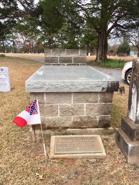
William Ayes Crawford's grave in the northwestern corner of the Lee Cemetery near the Military Road. William A Crawford, Col Crawford's Regt Ark Cav, Mexican War CSA, Jun 24 1825 - Jul 23 1874
Photo by Steve Perdue
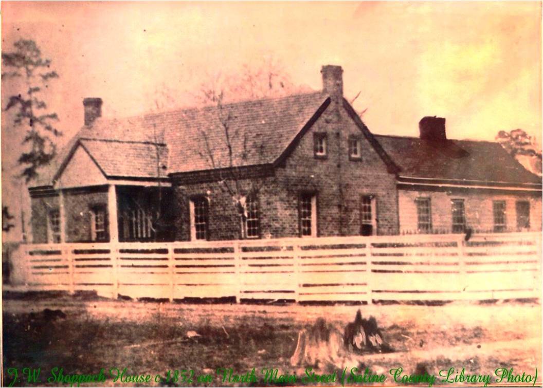
John F. Shoppach House Marker
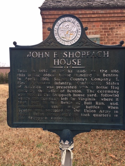
Built in 1852 of bricks made on site, this is the oldest house standing in Benton. In April 1861, Saline County's Company E, First Arkansas Infantry, Confederate States of America, was presented with a battle flag made by the ladies of Benton. The ceremony was held in the Shoppach house yard, following which the company left for Virginia, where it took part in the Battle of Bull Run, and, subsequently, other major battles. When Benton was occupied by the Union Army in 1863, Union Army officers took quarters in the Shoppach house.
Photo by Steve Perdue
John F. Shoppach House
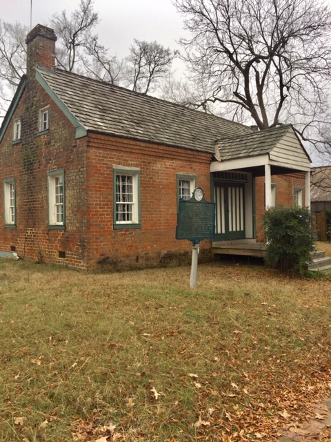
Modern-day photo of the John F. Shoppach House. It's located in Benton, Arkansas, on the southeast side of the junction of Military Road and N Main Street.
Photo by Steve Perdue
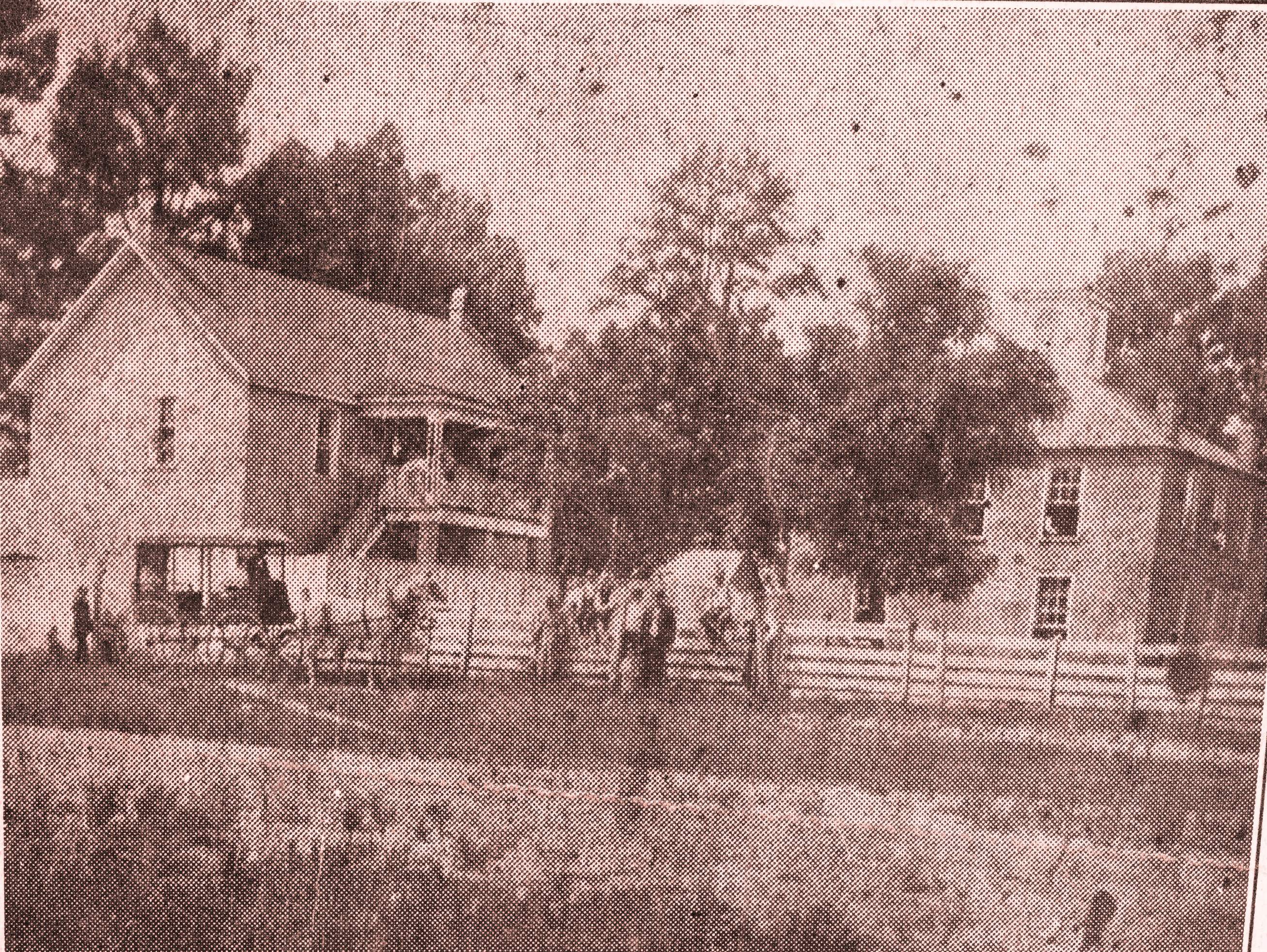
John F. Shoppach House
Civil War Era Photo of House
Image of Historic Photo by Steve Perdue
Saline County Courthouse
The Saline County Courthouse at the time of the Civil War had been built in 1856. It remained in use until the beginning of the twentieth century. Charles L. Thompson, a well-known Little Rock architect, designed the current courthouse which was completed in 1902. It was renovated and expanded in 1939 and expanded again in 1983.
Scanned by Steve Perdue
Saline County in the Civil War Marker

Civil War markers and other monuments are on the grounds of today's courthouse.
A Civil War marker facing Main St. stands on the east side of the courthouse in front of the gazebo. The two-sided marker entitled "Saline County in the Civil War" recounts the major events that occurred in the county including the Camden Expedition.
Saline County held 6,640 people in 1860, including 749 slaves. Jabez M. Smith, the county's secession convention delegate, voted to leave the Union. The Saline Guards formed in 1861 and became Co. E, 1st Arkansas Infantry (C.S.). Their captain, James Fagan, ended the war a major general. As many as 1,300 Saline County men in 24 companies fought for the Confederacy; two companies of local men formed for Union service. The Union army occupied Benton in late 1863 and built fortifications including one that was named after Col. Cyrus Bussey. (Continued on other side)
Photo by Steve Perdue
Saline County in the Civil War Marker
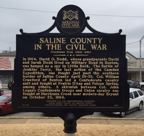
(Text continued from other side of marker.)
David O. Dodd, whose grandparents David and Sarah Dodd lived on Military Road in Benton, was hanged as a spy in Little Rock. The Battle of Jenkins' Ferry, the last action of the Camden Expedition, was fought just past the southern border of Saline County April 29-30. Col. William Crawford of Benton led a Confederate cavalry unit and fought at Prairie D'Ane and Poison Spring, among others. A skirmish between Col. John Logan's Confederate troops and Union Cavalry was fought at Hurricane Creek near modern-day Bryant on October 23, 1864.
Photo by Steve Perdue
After its occupation in late 1863, Benton also became a point where Unionists or disaffected Confederates could contact or join the Union Army.
Saline County Records Marker
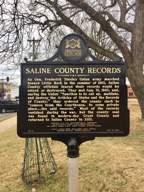
A second Civil War marker is on the courthouse grounds and faces West Sevier St. on the south side of the courthouse. This marker entitled "Saline County Records" commemorates the loss of records during the Civil War.
As Gen. Frederick Steele's Union army marched toward Little Rock in the summer of 1863, Saline County officials feared their records would be seized or destroyed. They met Aug. 31, 1863, and, saying the Union "function is to cut up, mutilate, and destroy the Articles of States and the Records of County", they ordered the county clerk to "remove from the Courthouse, to some private place ... the said records." Most of the records vanished during the war, but the county seal was found in modern-day Grant County and returned to Saline County in 2013.
Photo by Steve Perdue
Up Next
This brings us to the next point of interest, Saline River and Rural Saline County.