


Summary
March 25-April 1, 1864. Steele'™s column having marched through Benton crossed the Saline River without difficulty and moved on to Rockport in Hot Spring County. Travelling on the Military Road with occasional skirmishes with Confederates, Steele reached Rockport on March 27. Using his pontoon bridge, he crossed the Ouachita River and continued on the Military Road through Hot Spring County to Clark County and Arkadelphia, having planned to meet Thayer's force from Fort Smith by April 1.
The Route
▷ We previously began at Saline River and Rural Saline County, ending on US 67 at the Saline County / Hot Spring County line, which is our starting point.
▷ US67 crosses Saline/Hot Spring County Line, ARContinue on U.S. Hwy 67 about 8.5 miles.
▷ US 67 runs with US 270B, Malvern ARUS 67 runs with US 270B in Malvern for another 2.7 miles.
▷ US 270B at Main St, Malvern ARTurn right (northward) onto Main Street/US 270B, which becomes Martin Luther King Boulevard, and go about 1.9 miles.
▷ US 270B / Martin Luther Kind Blvd at Tanner Street, Malvern ARTurn left (westward) onto Tanner Street for about a half mile.
▷ Tanner St at Riverview Dr, Malvern ARTurn right (northward) onto Riverview Drive and proceed along the river, under I-30, about 3/4 miles to the Ouachita River Whitewater Park. The Union Army crossed the Ouachita on a pontoon bridge near here.
▷ Ouachita River Whitewater Park, Malvern ARBegin your return to US 67 using the same route, southward 3/4 miles to Tanner Street.
▷ Riverview Dr at Tanner Street, Malvern ARTurn left (eastward) 1/2 mile to U.S. 270B South/MLK.
▷ Tanner St at US 270B / Martin Luther Kind Blvd, Malvern ARTurn right (southward). But go only a quarter-mile.
▷ US 270B at Park Drive, Malvern ARTurn left onto Park Drive and immediately left to the parking spaces on Pavillion Drive.
▷ Park Drive at Pavilion Road, Malvern ARThe two-sided marker is located here. In order to leave the park, you may need to loop to the left (northward) then west on Rodeo Drive.
▷ Pavilion Road at US270B/MLK, Malvern ARLeave the park by turning left (southward) and continue along US 270B/MLK the remaining 1.6 miles to US 67.
▷ US 270B at US 67, Malvern ARTurn right (westward) onto US 67 South for 13.4 miles. Along the way you will pass Donaldson and cross the Ouachita River.
▷ US 67 at Ouachita River, Hot Spring/Clark County LineAfter crossing the Ouachita River, continue westward on US 67 south for 0.6 mile.
▷ US 67 at Arkansas 15, Clark Co ARTurn right (northward) onto County Road 15 / Midway Road. Travel about 7.7 miles to Social Hill. This road follows the alignment of the original Military Road taken by the Union Army.
▷ Adkins Memorial United Methodist Church, Social Hill, ARSocial Hill is just east of I-30 Exit 91. Return to US 67 by back-tracing your route.
▷ US 67 at Arkansas 15, Clark Co ARTurn right (or continue if you did not go to Social Hill) on US 67 south for 7.1 miles. Pass through Friendship before reaching Caddo Valley.
▷ US 67 merges with Arkansas 7, Caddo Valley ARAt the stop sign in Caddo Valley, US 67 merges with Arkansas 7 into Arkadelphia.
▷ The Byway brings us to the next point of interest, Arkadelphia and Clark County.
Google Maps
Show my location on map
At the popup, you must allow your web brower (not us) to know your location.
Your location should update every 5 seconds.
The Byway brings us to the next point of interest, Arkadelphia and Clark County.
Acme Brick
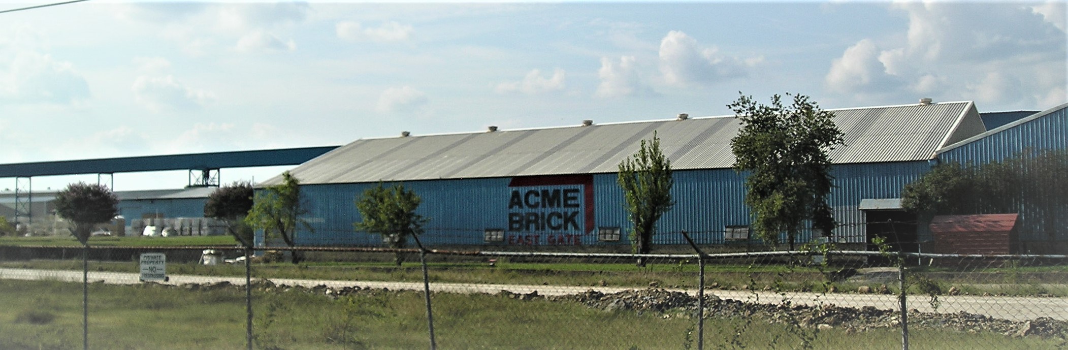
Acme Brick is the largest maker of bricks in Arkansas and one of the largest brick-making concerns in the United States. It is a landmark in Perla, Arkansas, near Malvern, the county seat of Hot Spring County.
Photo by Peggy Lloyd
Perla and the Malvern Lumber Company
Adalbert Strauss, a native of Germany, established the Malvern Lumber Company in 1880. He purchased timberland, constructed a sawmill and planer mill and built housing for his employees. He named the new town for his oldest daughter Perla Marie Strauss. Though started as a timber town, clay deposits were in the area, and brickmaking also became a local industry. Acme Brick, started in Texas in 1891, built a plant in Perla in 1919 and purchased an older existing brickmaking concern in 1926. The coming of Acme Brick became the most important event in the town's history. With many African American workers in the industries, Perla also became the site of a Rosenwald School for the children of Black families in 1925-26.
Malvern
Nearby Malvern, a railroad town founded by the Cairo and Fulton Railroad in 1873, is the next town on the Byway. A Cairo and Fulton railroad employee suggested the name "Malvern" for this railroad stop. The name came from Malvern Hills, a place in Virginia whose terrain reminded him of this stop in Arkansas. Malvern became the county seat in 1879. It too benefited from the timber and brickmaking industries and became the largest city in the county. Today it touts itself as the brick capital of the world and has celebrated the annual "Brickfest" since 1981. The festival is now held on the last full weekend in June. The Hot Spring County Museum is also in Malvern. Located in the Boyle House at 302 East Third St., this local history museum contains a variety of exhibits and is open from Wednesday to Friday from 12:30 to 4:30.
Rockport
The Camden Expedition Scenic Byway runs through Perla and Malvern to the eastern bank of the Ouachita River at Rockport where the Union Army crossed using a pontoon bridge. Rockport derives its name from the boulders in the river and from being a port in the era when river travel was important, roads were poor or non-existent and rail travel was decades away. One of the early named places in Arkansas,
Rockport served as the county seat of Hot Spring County from 1846 to 1879 and was a destination of Steele's force on its way to Arkadelphia and beyond. Today it is a mix of the old and the modern. Historic sites are near modern motels, fast food restaurants, convenience stores, strip malls and a Wal-Mart Super Center to serve the community and travelers on nearby Interstate 30.
Ouachita River at Rockport
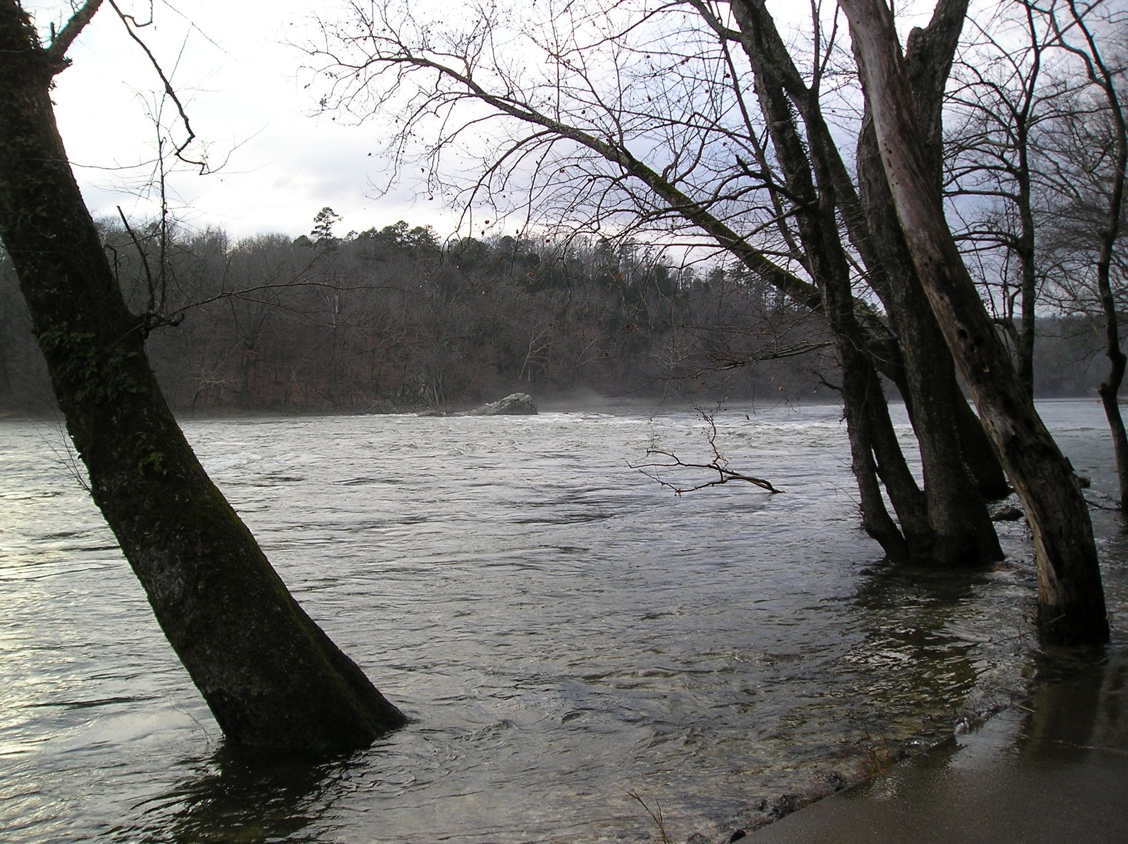
The river behind Wal-Mart is scenic and attracts many visitors to fish, go boating, kayaking or canoeing or just to watch. Lake DeGray State Park and Lodge are nearby on Highway 7 toward Hot Springs and offer scenic views and many recreational activities. The Byway stops at a city park on its way back to downtown Malvern and Highway 67 to visit a Civil War Sesquicentennial marker that details the events at Rockport of more than 155 years ago and the importance of the pontoon bridge the Union Army carried on its expedition.
Photo by Peggy Lloyd
Bridging the Ouachita River Marker
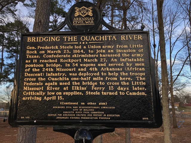
Gen. Frederick Steele led a Union army from Little Rock on March 23, 1864, to join an invasion of Texas. Confederate skirmishers harassed the army as it reached Rockport March 27. An inflatable pontoon bridge, in 34 wagons and served by men of the 24th Missouri and 4th Arkansas (African Descent) Infantry, was deployed to help the troops cross the Ouachita one-half mile from here. The Federals again used the bridge to cross the Little Missouri River at Elkins' Ferry 13 days later. Critically low on supplies, Steele turned to Camden, arriving April 15. (continued on other side)
Photo by Melissa Phillips
Bridging the Ouachita River Marker
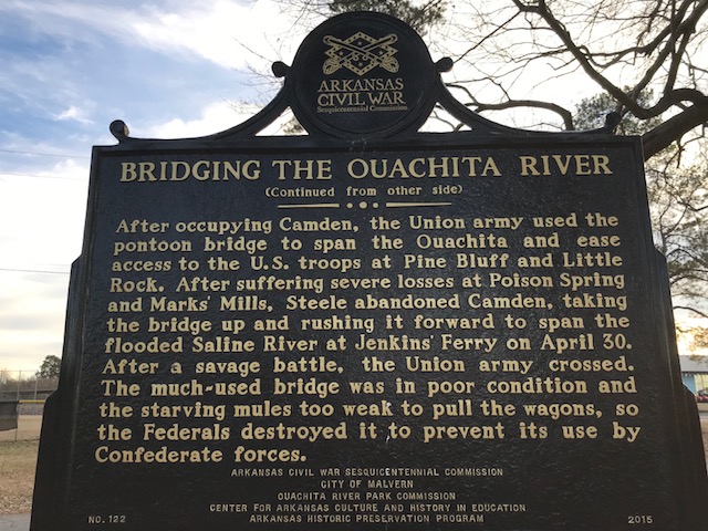
(Continued from other side) After occupying Camden, the Union army used the pontoon bridge to span the Ouachita and ease access to the U.S. troops at Pine Bluff and Little Rock. After suffering severe losses at Poison Spring and Marks' Mills, Steele abandoned Camden, taking the bridge up and rushing it forward to span the flooded Saline River at Jenkins' Ferry on April 30. After a savage battle, the Union army crossed. The much-used bridge was in poor condition and the starving mules too weak to pull the wagons, so the Federals destroyed it to prevent its use by Confederate forces.
Photo by Melissa Phillips
Donaldson
The Byway continues southwest from Malvern on US 67 through Donaldson, a railroad town that did not exist at the time of the Civil War. Founded by the Cairo and Fulton Railroad in 1873, it is named for William Rhind Donaldson (1843-1917), a St. Louis lawyer,
who in 1869 had married Elizabeth Larned Allen (1843-1909), the oldest daughter of Thomas Allen, the president of the Cairo and Fulton Railroad.
Midway
Located in southern Hot Spring County, Midway emerged along one of the roads associated with the Southwest Trail. It may have derived its name from being halfway between Little Rock in Pulaski County and Fulton, an early town on the Red River in Hempstead County on the way to Texas, or from being halfway between Rockport and Arkadelphia. Midway had a post office as early as 1850 but was bypassed by the Cairo and Fulton Railroad when it was built through the region in 1873. The importance of the community diminished over time, and it remained centered on agriculture. The citizens voted to incorporate in 2000. A recently installed historic marker stands in front of the Midway Town Hall and Community Center. It notes the early history of the town and its role in the Civil War and the Camden Expedition.
Military Road Marker
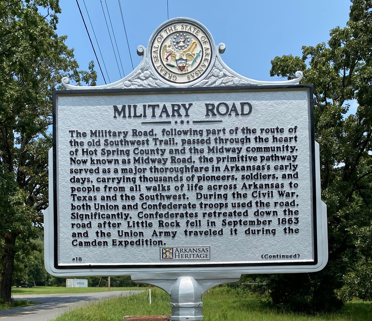
The Military Road, following part of the route of the Old Southwest Trail, passed through the heart of Hot Spring County and Midway. Now known as Midway Road, the primitive pathway served as a major thoroughfare in Arkansas's early days, carrying thousands of pioneers, soldiers and people from all walks of life across Arkansas to Texas and the Southwest. During the Civil War, both Union and Confederate troops used the road. Significantly, Confederates retreated down the road after Little Rock fell in September 1863 and the Union Army travelled it during the Camden Expedition.
Photo by Wendy Richter
Settlement of Midway Marker
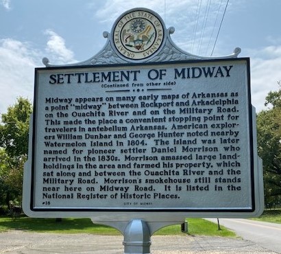
(Continued from other side.) Midway appears on many early maps of Arkansas as a point "midway" between Rockport and Arkadelphia on the Ouachita River and on the Military Road. This made the place a convenient stopping point for travelers in antebellum Arkansas. American explorers William Dunbar and George Hunter noted nearby Watermelon Island in 1804. The island was later named for pioneer settler Daniel Morrison who arrived in the 1830s. Morrison amassed large landholdings in the area and farmed his property, which sat between the Ouachita River and the Military Road. Morrison's smokehouse still stands near here on Midway Road. It is listed in the National Register of Historic Places.
Photo by Wendy Richter
Social Hill
Social Hill was an early farming community near the junction of the Ouachita River and the Old Military Road. It is located in the hills seven miles southwest from where the Union Army crossed the Ouachita River on the Old Military Road. Many early roads in Arkansas stayed on ridge lines, and many early settlements started high on hills to avoid the mosquito-infested lowlands that produced malaria and other deadly fevers. Adam Blakely (1809-1860) settled in the area in the 1820s and built a dogtrot log house high on Social Hill in 1837 at about the same time that he acquired legal title to farmland along the Ouachita River by land patent. He could farm the rich river bottoms but reside in health and safety on the nearby highlands.
Years later in 1935 Homer Martin Adkins (1890-1964) and his wife bought Blakely's old log house as a summer home. At the time, Adkins served as Arkansas collector of internal revenue under the Depression-era Roosevelt administration. Already deeply involved in state politics, Adkins, a Democrat, would later serve as the 32nd governor of Arkansas from 1941 to 1945. He and his wife also became interested in a nearby Methodist Church and aided in the rebuilding of the church. In gratitude the church took the name of the Adkins Memorial Methodist Church. The church is today a major landmark in the Social Hill community and has a sizeable cemetery behind it that includes the graves of some veterans of the Civil War. The church and cemetery are very near Interstate 30. Cars and trucks whizzing by on this busy Interstate are visible through the trees and bushes that border the church and cemetery. The Interstate and Highway 84 which comes up from the Ouachita River at Rockport are accessible from Social Hill. The Byway spur returns to Highway 67 via Midway Road.
Years later in 1935 Homer Martin Adkins (1890-1964) and his wife bought Blakely's old log house as a summer home. At the time, Adkins served as Arkansas collector of internal revenue under the Depression-era Roosevelt administration. Already deeply involved in state politics, Adkins, a Democrat, would later serve as the 32nd governor of Arkansas from 1941 to 1945. He and his wife also became interested in a nearby Methodist Church and aided in the rebuilding of the church. In gratitude the church took the name of the Adkins Memorial Methodist Church. The church is today a major landmark in the Social Hill community and has a sizeable cemetery behind it that includes the graves of some veterans of the Civil War. The church and cemetery are very near Interstate 30. Cars and trucks whizzing by on this busy Interstate are visible through the trees and bushes that border the church and cemetery. The Interstate and Highway 84 which comes up from the Ouachita River at Rockport are accessible from Social Hill. The Byway spur returns to Highway 67 via Midway Road.
Adkins Memorial United Methodist Church, Social Hill, AR
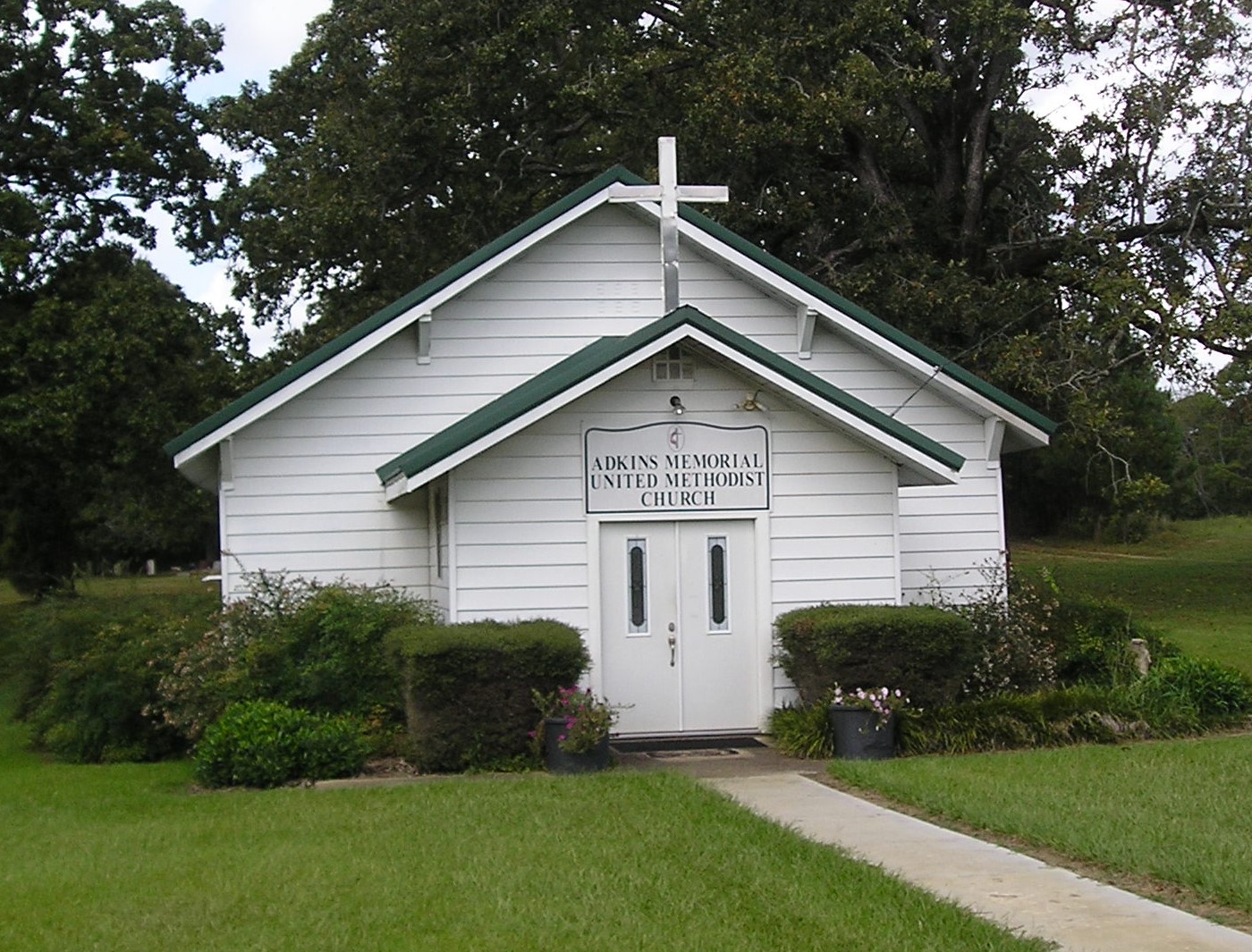
This church was founded in 1874 as Pisgah Methodist and then named Lone Hill Methodist before becoming Social Hill Methodist. Funding of the new building by Homer Adkins led to its current name of Adkins Memorial Methodist Church.
Photo by Peggy Lloyd
Friendship
After the spur, the next town on the road to Clark County and Arkadelphia at the time of the Civil War was Friendship. It was founded in the 1850s and took its name from the congenial relationships among the early settlers. Located some four miles from the confluence of the Caddo and Ouachita Rivers along the Clark County line, Friendship had another asset: salt deposits. With the men serving in the Confederate Army, the local women struggled to work the salt deposits near their town and to transport quantities of salt for their own use and for the support of regional industries. Salt was a valuable and much needed commodity that was in short supply in much of the South, and that shortage seriously hampered the efforts of Confederate industries. Before refrigeration, salt was important for the preservation of food and for use in the tanning of leather for shoes, harness, bridles and other leather products. Many of these items were produced in nearby Arkadelphia and required salt for tanning.
Up Next
The Byway brings us to the next point of interest, Arkadelphia and Clark County.