


Summary
April 26-29, 1864. Having decided to retreat to Little Rock via Jenkins' Ferry while he still had an army to save, Steele abandoned Camden. The Confederate cavalry pursued him, catching up with his force on the Old Camden Road at Guesses Creek. After skirmishing, the Federals moved on toward the Saline Bottoms in a driving rainstorm.
The Route
▷ We previously began at Princeton, ending on Arkansas 46 at Leola, which is our starting point.
▷ Grant 1 at Arkansas 46, Leola ARTurn right (eastward) onto Arkansas 46 for 3 blocks (0.2 mile).
▷ Arkansas 46/12th Avenue at Main Street, Leola ARTurn left (north) onto Main Street for 0.7 mile.
▷ Arkansas 46/Main Street at Arkansas 229, Leola ArBear right (northeast) to stay on Arkansas 46 for 0.5 mile.
▷ Arkansas 46 at Grant County 6, Grant County ARTurn left (north) onto Grant 6, a total of 1.5 miles, through piney wood and past fields, including a left (westward) curve, followed by another left (southwestward) curve.
▷ Grant 1 at Arkansas 46, Leola AR 229, Grant County ARTurn left (south) on Arkansas 229 for about 300 feet. The Confederate Headquarters/Confederate Flank Attack, Civil War Sesquicentennial marker, is on the left.
▷ Confederate Headquarters/Confederate Flank Attack Marker, Leola ARProceed southward for 0.6 mile to the intersection of Arkansas 229 and Arkansas 46.
▷ Arkansas 229 at Arkansas 46, Leola ARAt the Arkansas 229/Arkansas 46 junction, turn left onto Arkansas 46 toward Sheridan for 3.7 miles.
▷ Jenkins' Ferry State ParkArrive at Jenkins Ferry State Park.
▷ This brings us to the next point of interest, Jenkins' Ferry.
Google Maps
Show my location on map
At the popup, you must allow your web brower (not us) to know your location.
Your location should update every 5 seconds.
This brings us to the next point of interest, Jenkins' Ferry.
Leola
The Byway continues through the town of Leola, a town which did not exist at the time of the Civil War, then moves on to the Civil War Sesquicentennial marker at the intersection of Arkansas 46 and Grant County Road 6.
Timber Mill at Leola
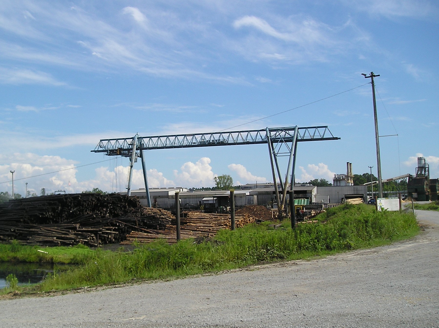
Leola is a timber mill town in Grant County, Arkansas. Formerly known as Sandy Springs, it developed rapidly after the coming of the Rock Island Railroad in 1905 as a timber town and remains one today although it struggled to survive during the Great Depression of the 1930s. At the time of the Civil War, the area was sparsely populated by farmers who worked the rich alluvial soils along the Saline River. A local family named Jenkins operated a ferry on the Saline a few miles from the community of then Sandy Springs. Known as Jenkins' Ferry, it would lend its name to a bloody battle and the last major engagement of the Camden Expedition.
Photo by Peggy Lloyd
Markers on Grant County 6
Grant County Road 6 loops through a neighborhood just outside the city limits of Leola. The Civil War Sesquicentennial markers along this road that circles around just south of Cox Creek tell a tale of the suffering of soldiers and civilians and of the desperation, devastation and atrocities of war near Jenkins' Ferry. Cox Creek runs through the low-lying bottom lands to empty into the Saline River at Jenkins Ferry. The existing military road ran along the south side of Cox's Creek. Fighting took place in these bottom lands with Union rearguard troops protecting the retreat of General Steele's army over the pontoon bridge they had deployed at Jenkins' Ferry to escape the Confederate forces pursuing them.
Officers Killed Marker
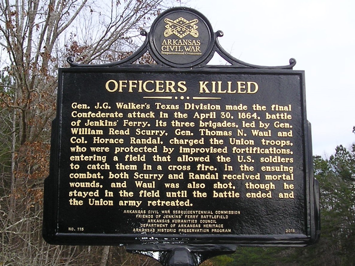
This side of the Civil War Sesquicentennial marker at the intersection of Arkansas 46 and Grant County Road 6 recounts the deaths of prominent Confederate officers.
Gen. J. G. Walker's Texas Division made the final Confederate attack in the April 30, 1864, battle of Jenkins' Ferry. Its three brigades led by Gen. William Read Scurry, Gen. Thomas N. Waul and Col. Horace Randal, charged the Union troops who were protected by improvised fortifications, entering a field that allowed the U.S. soldiers to catch them in a cross fire. In the ensuing combat, both Scurry and Randal received mortal wounds, and Waul was also shot though he stayed in the field until the battle ended and the Union Army retreated.
The burials of Scurry and Randal and their later removal to Texas were mentioned in the stop at the Tulip Methodist Church in Dallas County with its large cemetery.
Photo by Peggy Lloyd
Union Wounded Marker

The other side of the two-sided marker details the suffering of ordinary Union soldiers.
Many of the most seriously wounded Union soldiers were left behind after the battle of Jenkins' Ferry. William Nicholson, the surgeon of the 29th Iowa Infantry, and a pair of stewards stayed behind to care for them. Nicholson reported that Confederate soldiers killed several men from the 2nd Kansas Colored Infantry Regiment. Dozens of other wounded Union soldiers were moved south to hospitals in Princeton, where many succumbed to their wounds, later being moved to the Little Rock National Cemetery where they remain today.
The next marker on Grant County Road 6 deals with the hardships and devastation suffered by the civilian population in the area.
Photo by Peggy Lloyd
The Price of War Marker
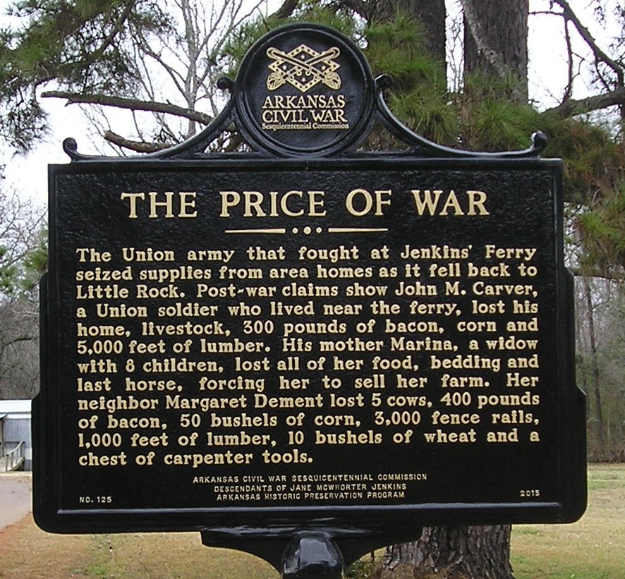
This two-sided marker details the suffering and losses of individual families in the area.
The Union Army that fought at Jenkins' Ferry seized supplies from area homes as it fell back to Little Rock. Post-war claims show John M. Carver, a Union soldier who lived near the ferry, lost his home, livestock, 300 pounds of bacon, corn and 5,000 feet of lumber. His mother Marina, a widow with 8 children, lost all her food, bedding and last horse, forcing her to sell her farm. Her neighbor Margaret Dement lost 5 cows, 400 pounds of bacon, 50 bushels of corn, 3,000 fence rails, 1,000 feet of lumber, 10 bushels of wheat and a chest of carpenter's tools.
These devastating losses threatened families with immediate starvation and poverty that would be difficult to overcome. Civilians who had suffered losses had to wait until 1871 to apply to the postwar Southern Claims Commission for compensation, and they had to prove that they had been loyal supporters of the Union in order to make a claim. Fewer than a third of the total applications were approved.
Photo by Peggy Lloyd
Fields of Battle Marker
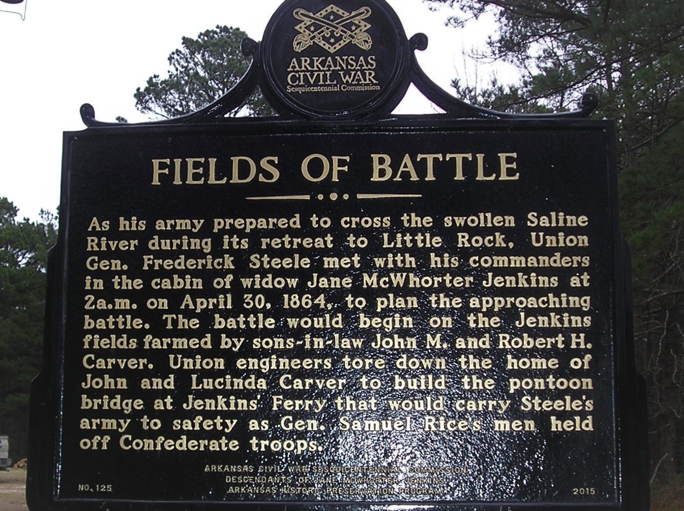
This side of this marker gives details on Steele's preparation for the battle on April 30 and the loss members of the Jenkins family suffered.
As his army prepared to cross the swollen Saline River during its retreat to Little Rock, Union Gen. Frederick Steele met with his commanders in the cabin of Jane McWhorter Jenkins at 2 A. M. on April 30, 1864, to plan the approaching battle. The battle would begin on the Jenkins fields farmed by sons-in-law John M. and Robert H. Carver. Union engineers tore down the home of John and Lucinda Carver to build the pontoon bridge at Jenkins' Ferry that would carry Steele's army to safety as Gen Samuel Rice's men held off Confederate troops.
The fields of battle literally took place in the fields cultivated by local farmers. The fields were open areas in otherwise densely forested lowlands with sometimes almost impenetrable underbrush growing in the rich alluvial soil. With the passage of hundreds of wagons, thousands of horses and mules and thousands of advancing soldiers of both sides, these roads and fields quickly became difficult mud pits where sometimes wagons had to be abandoned or burned and heavy artillery simply had to be left.
Photo by Peggy Lloyd
Confederate Headquarters Marker
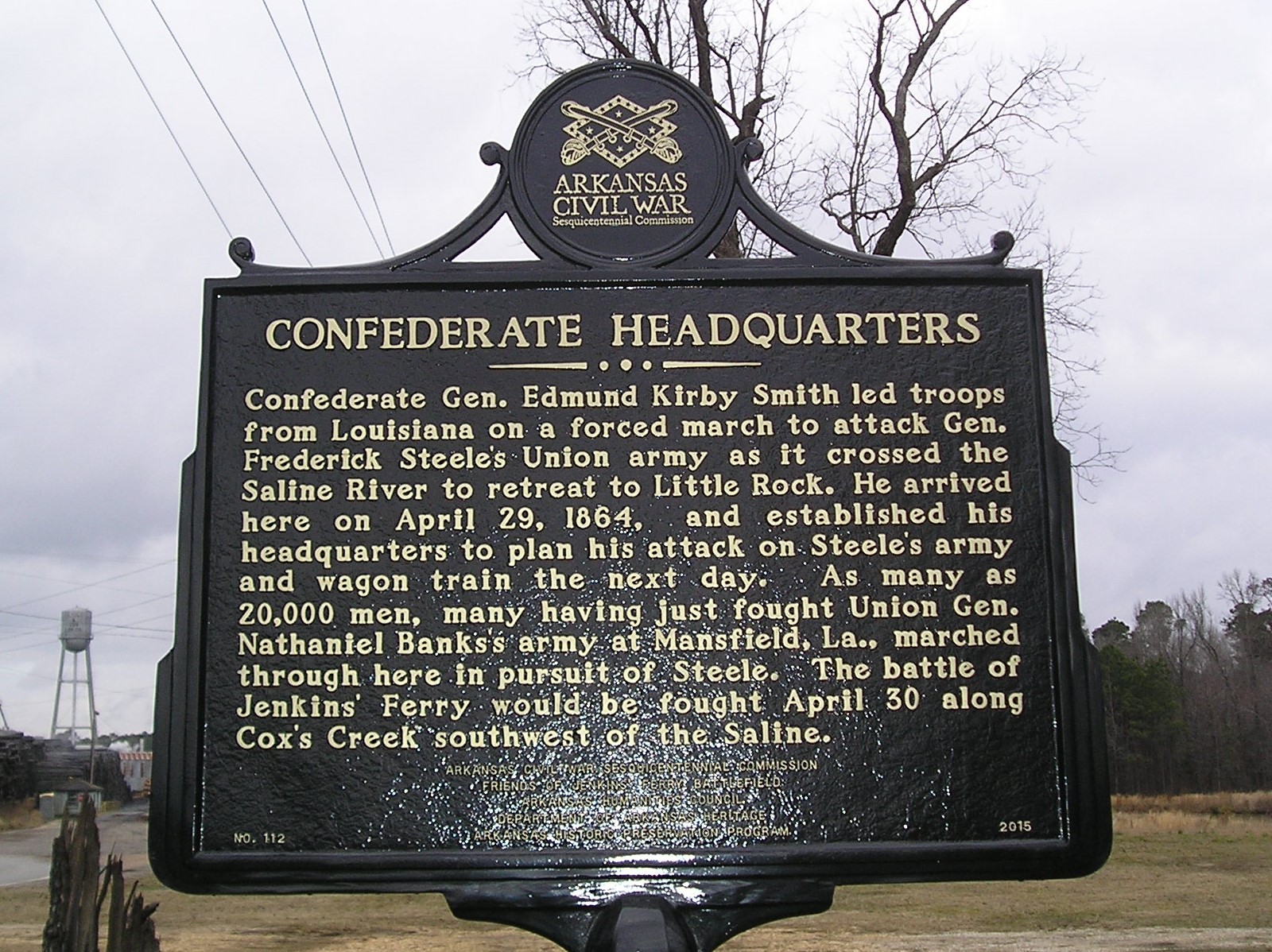
Confederate Gen. Edmund Kirby Smith led troops from Louisiana on a forced march to attack Gen. Frederick Steele's Union army as it crossed the Saline River to retreat to Little Rock. He arrived here on April 29, 1864 and established his headquarters to plan his attack on Steele's army and wagon train the next day. As many as 20,000 men, many having just fought Union Gen. Nathaniel Banks's army at Mansfield, La., marched through here in pursuit of Steele. The battle of Jenkins' Ferry would be fought April 30 along Cox's Creek southwest of the Saline.
Smith's force outnumbered that of Steele's, but the terrain in the Saline Bottoms ---the location of Cox's Creek swollen by heavy rains and the heavily forested wet swamp lands along the Military Road---gave Steele and his men problems with bogged down wagons. However, it also offered them an advantage over Confederate soldiers attempting to charge their quickly constructed fortifications.
Photo by Peggy Lloyd
Confederate Flank Attack Marker
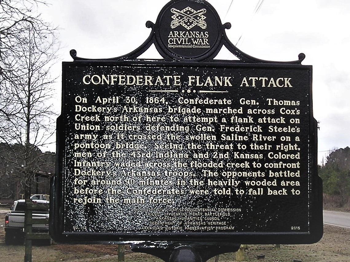
On April 30, 1864, Confederate Gen. Thomas Dockery's Arkansas brigade marched across Cox's Creek north of here to attempt a flank attack on Union soldiers defending Gen. Frederick Steele's army as it crossed the swollen Saline River on a pontoon bridge. Seeing the threat to their right, men of the 43rd Indiana and 2nd Kansas Colored Infantry waded across the flooded creek to confront Dockery's Arkansas troops. The opponents battled for around 90 minutes in the heavily wooded area before the Confederates were told to fall back to rejoin the main force.
Not far away, the Confederate commander of the Trans-Mississippi established his command post and made his plans for the pending fight.
In the soggy Saline bottoms such flanking strategies did not work out well nor did charging unit after unit at the Union rearguard that had dug in to protect their comrades struggling to get the wagon train across the pontoon bridge. Various Confederate units charged and threatened the Union rearguard for a time but then had to pull back after experiencing casualties to regroup at different times during the battle. By afternoon, the Union rearguard commander was ready to pull back close to the Saline when he learned from General Steele that the wagon train was across the river. Steele was ready to take the remaining force to the eastern bank. The Confederate Army, having suffered substantial casualties and with no pontoon bridge to cross the flooded stream, was in no position to continue the pursuit.
Photo by Peggy Lloyd
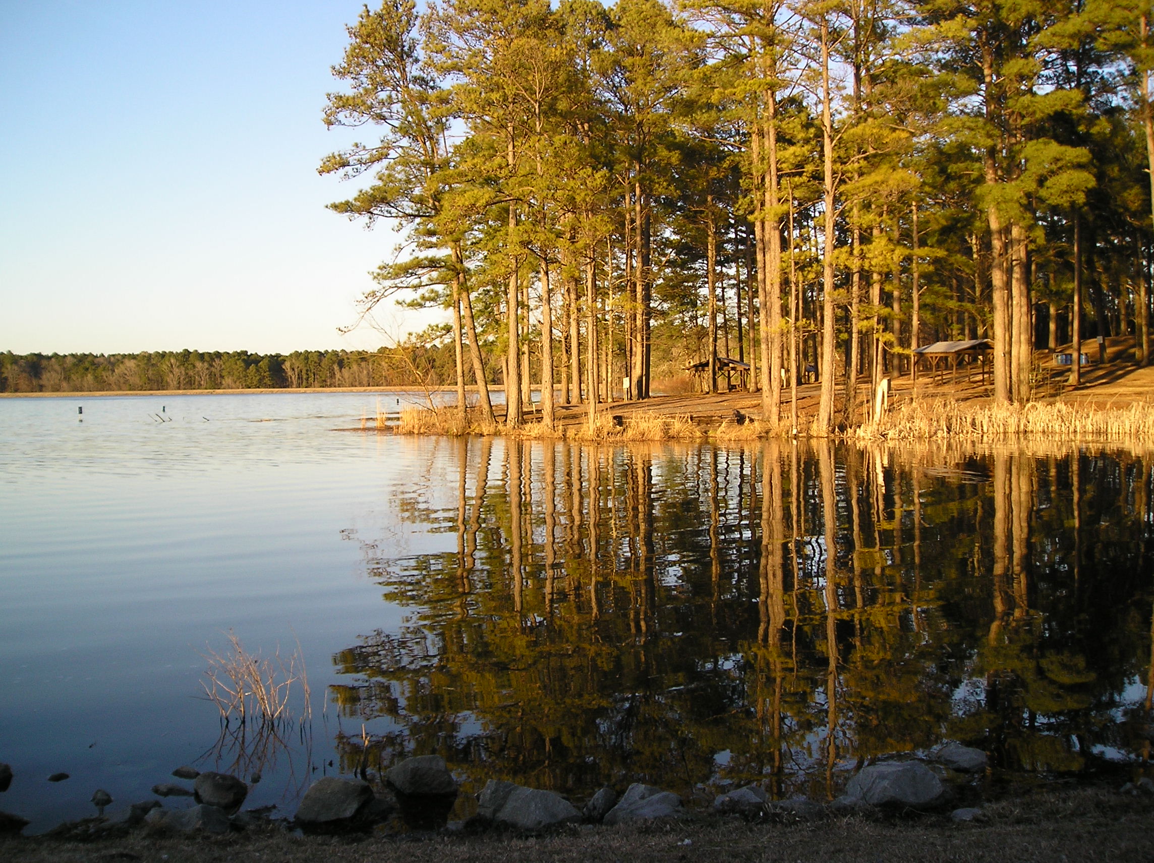
Cox Creek Lake Just West of Leola

Cox Creek flows through Grant County into the Saline River. In 1964 Arkansas Game and Fish created Cox Creek Public Fishing Lake west of Leola. Cox Creek passes through the Jenkins' Ferry Battleground site near Leola, and it may be of interest to visitors to the Civil War sites in the area. The lake is about 266 acres. It is scenic and offers opportunities for boating, fishing, camping and photography.
Photo by Peggy Lloyd
Cox Creek Lake and Campground
The campground shown here on the shore of the lake provides sites for RV and tent camping with electricity, a restroom and shower facility, a large fishing pier, and boat launch area with parking. A camp host is on site. Additional information is available regarding fees and the site from the office of the county judge in the Grant County Courthouse in Sheridan, Arkansas.
Photo by Peggy Lloyd
Up Next
This brings us to the next point of interest, Jenkins' Ferry.